MISSOULA FLOODS
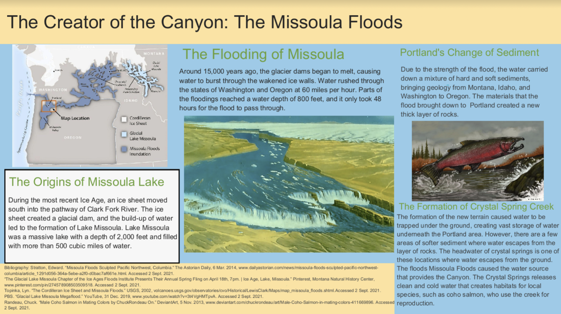
THE ORIGINS OF REED LAKE AND THE MISSOULA FLOODS
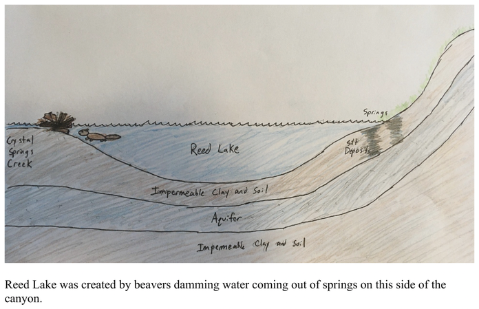
If you entered from the other side of the canyon, you may have noticed that there is a creek where water drains from the lake. But on this side of the canyon, there are no streams flowing into the lake. So where is the water coming from? In fact, Reed lake is a spring-fed lake (Perry, 2021) This means the water in the lake comes from deep underground instead of surrounding streams or rivers. The water in Reed Canyon comes 3-4 larger springs and several smaller springs, located at the base of the hill (Adolfson Associates Inc, 2001). Water from the spring flows into Crystal Springs Creek, on the other side of the canyon. In the 1800s, beaver activity slowed the amount of water going into the creek, so the water from the springs pooled and created Reed Lake, which continues to be fed by the springs today (Lam, 2020)
But where did the springs come from?
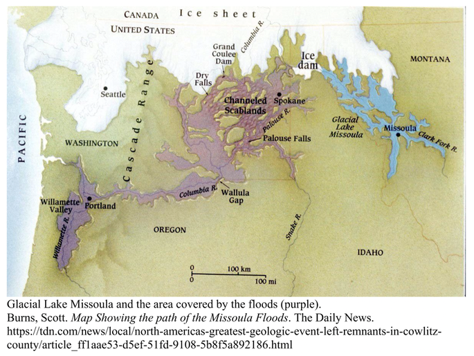
At the end of the last Ice age, around 15,000 years ago, the Cordilleran Ice Sheet covered Northern Washington and Idaho (Oregon Department of Geology and Mineral Industries, n.d). The ice from the glacier dammed the mouth the Clark Fork River, creating the massive Glacial Lake Missoula (USGS, 2002). The top of the ice dam broke and water from the lake burst out of the lake at 65 miles per hour (USGS, 2002). The water, along with many tons of silt, sand, and gravel rushed across Washington into the Columbia river and into the Willamette Valley (Oregon Department of Geology and Mineral Industries, n.d). As the Cordilleran Ice Sheet continued to move southwards, the dam reformed and broke repeatedly, creating dozens of floods over the next 2,500 years (USGS, 2002). These floods brought layers of soil into the Willamette valley that are so dense that water can’t get through them (Perry, 2021). But some places, like this one, have deposits of silt loose enough for water from underground aquifers to rise to the surface, creating springs (Perry, 2021).
But where did the springs come from?
At the end of the last Ice age, around 15,000 years ago, the Cordilleran Ice Sheet covered Northern Washington and Idaho (Oregon Department of Geology and Mineral Industries, n.d). The ice from the glacier dammed the mouth the Clark Fork River, creating the massive Glacial Lake Missoula (USGS, 2002). The top of the ice dam broke and water from the lake burst out of the lake at 65 miles per hour (USGS, 2002). The water, along with many tons of silt, sand, and gravel rushed across Washington into the Columbia river and into the Willamette Valley (Oregon Department of Geology and Mineral Industries, n.d). As the Cordilleran Ice Sheet continued to move southwards, the dam reformed and broke repeatedly, creating dozens of floods over the next 2,500 years (USGS, 2002). These floods brought layers of soil into the Willamette valley that are so dense that water can’t get through them (Perry, 2021). But some places, like this one, have deposits of silt loose enough for water from underground aquifers to rise to the surface, creating springs (Perry, 2021).
Works Cited
Adolfson Associates, Inc. (2021). Crystal Springs Creek Fish and Wildlife Habitat Assesment.
https://www.reed.edu/canyon/reso/docs/2001_PPR.html
Lam, C. (2020, October 16). Canyon Column 2: The Introduction of a Restoration Strategy in 1999.
The Reed College Quest. https://reedquest.org/articles/2020/10/16/canyon-column-2-the-
introduction-of-a-restoration-strategy-in-1999
Oregon Department of Geology and Mineral Industries. (n.d.). Unit 17. Ice Age Floods: Oregon’s
best soils lifted from eastern Washington. Oregon: A Geologic History. Retrieved September 3,
2021, from https://www.oregongeology.org/pubs/ims/ims-028/unit17.htm
The Corilleran Ice Sheet and the Missoula Floods. (2002). USGS.
https://volcanoes.usgs.gov/observatories/cvo/Historical/LewisClark/Maps/map_missoula_floods.shtm
l
